…MAJOR HURRICANE MICHAEL GETTING MUCH BETTER ORGANIZED…
…LIFE-THREATENING STORM SURGE…HURRICANE FORCE WINDS…AND HEAVY RAINFALL EXPECTED ALONG THE NORTHEASTERN GULF COAST…
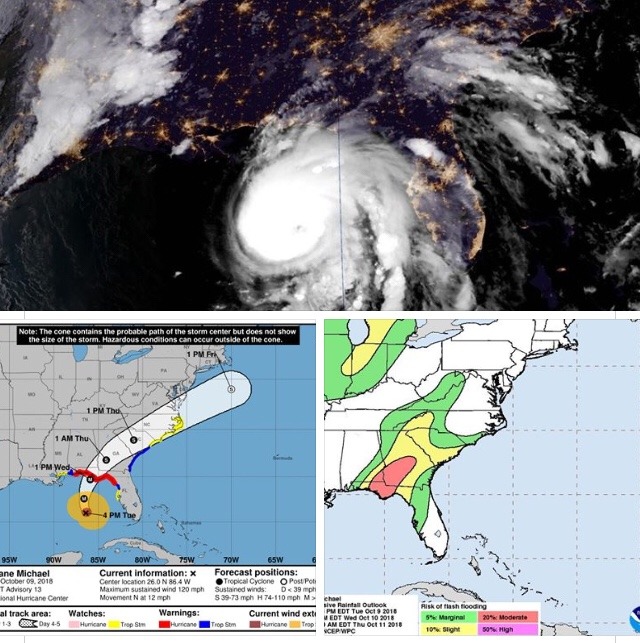
Hurricane Michael is centered as of 7 p.m. CDT over the eastern Gulf of Mexico about 255 miles (410 km) south of Panama City, Florida. On the forecast track, the center of Michael will move across the eastern Gulf of Mexico through tonight, then inland over the Florida Panhandle or Florida Big Bend area on Wednesday, then move northeastward across the southeastern United States Wednesday night and Thursday, and move off the Mid-Atlantic coast away from the United States on Friday.
Maximum sustained winds are near 120 mph (195 km/h) with higher gusts – a category 3 hurricane on the Saffir-Simpson Hurricane Wind Scale. Strengthening is expected overnight and on Wednesday, and Michael is forecast to be near category 4 strength when it makes landfall in the Florida Panhandle or the Florida Big Bend area. Weakening is expected after landfall as Michael moves across the southeastern United States. Hurricane-force winds extend outward up to 45 miles (75 km) from the center and tropical-storm-force winds extend outward up to 175 miles (280 km).
A Storm Surge Warning is in effect for from the Okaloosa/Walton County Line Florida to Anclote River, Florida. A Storm Surge Watch is in effect from Anclote River to Anna Maria Island, Florida, including Tampa Bay, and from the Alabama/Florida border to Okaloosa/Walton County Line Florida. A Hurricane Warning is in effect from the Alabama/Florida border to Suwannee River, Florida.
A Tropical Storm Warning is in effect from the Alabama/Florida border to the Mississippi/Alabama border; the Suwanee River to Chassahowitzka, Florida; and from Fernandina Beach, Florida, to South Santee River, South Carolina. A Tropical Storm Watch is in effect from Chassahowitzka to Anna Maria Island, Florida, including Tampa Bay; from the Mississippi/Alabama border to the Mouth of the Pearl River; and from the South Santee River, South Carolina, to Duck, North Carolina, including Pamlico and Albemarle Sounds. Interests elsewhere across the southeastern United States should monitor the progress of Michael. For storm information specific to your area, including possible inland watches and warnings, please monitor products issued by your local National Weather Service forecast office- www.weather.gov
The next complete advisory will be issued at 10 p.m. CDT at will be available at www.nhc.noaa.gov/#Michael